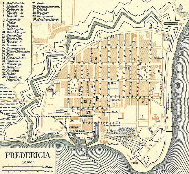
File:-Fredericia 1900.jpg

Original file (1,511 × 1,388 pixels, file size: 1.67 MB, MIME type: image/jpeg)
Captions
Captions
 | This image was uploaded in the JPEG format even though it consists of non-photographic data. This information could be stored more efficiently or accurately in the PNG or SVG format. If possible, please upload a PNG or SVG version of this image without compression artifacts, derived from a non-JPEG source (or with existing artifacts removed). After doing so, please tag the JPEG version with {{Superseded|NewImage.ext}} and remove this tag. This tag should not be applied to photographs or scans. If this image is a diagram or other image suitable for vectorisation, please tag this image with {{Convert to SVG}} instead of {{BadJPEG}}. If not suitable for vectorisation, use {{Convert to PNG}}. For more information, see {{BadJPEG}}. |
| Description-Fredericia 1900.jpg |
Dansk: Kort over Fredericia i det tidligere Vejle Amt
English: Map of Fredericia in Vejle County in Denmark |
|||||
| Date |
circa 1900 date QS:P,+1900-00-00T00:00:00Z/9,P1480,Q5727902 |
|||||
| Source | Frems Amtskort over Danmark | |||||
| Author | Fotolitograferede i Generalstabens Topografiske Afdeling | |||||
| Permission (Reusing this file) |
|
|||||
| Other versions | used in da:Fredericia, | |||||
| This is a retouched picture, which means that it has been digitally altered from its original version. Modifications: Fredericia omkring 1900. The original can be viewed here: Vejle Amt1900.jpg:
|
File history
Click on a date/time to view the file as it appeared at that time.
| Date/Time | Thumbnail | Dimensions | User | Comment | |
|---|---|---|---|---|---|
| current | 09:01, 12 March 2017 |  | 1,511 × 1,388 (1.67 MB) | Sebastian Wallroth (talk | contribs) | higher resolution |
| 11:25, 31 January 2009 |  | 1,548 × 1,432 (1.48 MB) | Cropbot (talk | contribs) | {{Information |Description=da:Kort over Vejle Amt <br/>en:Map of Vejle County in Denmark |Source=''Frems Amtskort over Danmark'' |Date=ca. 1900 |Author= Fotolitograferede i Generalstabens Topografiske Afdeling |Permission={{PD-old}} |other_versions= used |
You cannot overwrite this file.
File usage on Commons
The following 2 pages use this file:
File usage on other wikis
The following other wikis use this file:
- Usage on ar.wikipedia.org
- Usage on da.wikipedia.org
- Usage on de.wikipedia.org
- Usage on en.wikipedia.org
- Usage on et.wikipedia.org
- Usage on fa.wikipedia.org
- Usage on fr.wikipedia.org
- Usage on he.wikipedia.org
- Usage on hu.wikipedia.org
- Usage on ja.wikipedia.org
- Usage on nl.wikipedia.org
Metadata
This file contains additional information such as Exif metadata which may have been added by the digital camera, scanner, or software program used to create or digitize it. If the file has been modified from its original state, some details such as the timestamp may not fully reflect those of the original file. The timestamp is only as accurate as the clock in the camera, and it may be completely wrong.
| Horizontal resolution | 300 dpi |
|---|---|
| Vertical resolution | 300 dpi |
| Software used | paint.net 4.0.13 |
| File change date and time | 11:11, 31 January 2009 |
